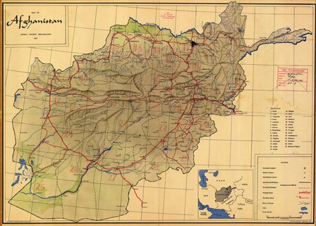
Maps of Afghanistan
Home > Maps
Map of
Kabul Airport
Menu
General |
Political |
City |
Ethnicity |
History |
Military Forces
Insurgency |
Warlords |
Topo |
Satellite |
Afghan Map Resources
Agriculture |
Misc |
News Articles
Return to Top of Page
General
Maps of Afghanistan
Afghanistan.
WorldAtlas.com.
Map of Afghanistan. By MapQuest.
Afghanistan. The Lonely Planet.
Map of Afghanistan. By National
Geographic Xpeditions. Interactive maps for non-commercial use.
Tactical Pilotage Chart. 1:500.000, Defense
Mapping Agency. University of Texas.
Transportation Map of Afghanistan. 1986,
University of Texas.
Afghanistan and Neighbors. Map by The
Washington Post.
Afghanistan. United Nations. (Acrobat Adobe PDF)
https://www.un.org/Depts/Cartographic/map/profile/afghanis.pdf
Afghanistan. WorldAtlas.com
https://www.worldatlas.com/maps/afghanistan
Google Map of Afghanistan.
Return to Top of Page
Political / Administrative Maps of Afghanistan
Afghan Provinces Map. GlobalSecurity.org.
City Maps of Afghanistan.
GlobalSecurity.org.
Political Map of Afghanistan.
University of Texas.
Afghanistan Administrative Units. UNOSAT.
Administrative Divisions of Afghanistan. The Embassy of Afghanistan,
London, United Kingdom
http://www.afghanistanembassy.org.uk/oldsite/dari/images/news_images/afghanistan_map.jpg
Map of Taliban Controlled and Contested Districts in Afghanistan -
Google (undated)
Return to Top of Page
City Maps of Afghanistan
Kabul. Circa 1986, DoS map, University of
Texas.
Kabul. Circa 1980, University of Texas.
Kabul. Circa 1985, Russian topo map.
University of Texas.
Herat. Circa 1998, University of Texas.
Herat. Circa 1985, Russian topo map,
1:200,000. University of Texas.
Jalalabad. Circa 1985, Russian topo map,
1:200,000. University of Texas.
Kandahar. Circa 1985, Russian topo map,
1:200,000. University of Texas.
Mazar-i-Sharif. Circa 1985, Russian topo
map, 1:200,000. University of Texas.
Tora Bora. Circa 1985, Russian topo map,
1:200,000. University of Texas.
Return to Top of Page
Maps of Ethnic Groups in Afghanistan
Ethnic Makeup of Afghanistan. CNN.com
Ethnic Map of Afghanistan. Le Monde
Diplomatique.
Population Density. GlobalSecurity.org.
Afghan Ethno-Linguistic Groups.
GlobalSecurity.org.
Ethno-linguistic Groups. UNOSAT.
Ethnicities in Afghanistan. 2009, University of
Texas Library.
Ethnolinguistic Groups in Afghanistan.
1997, University of Texas.
Ethnolingustic Groups. 1972, University
of Texas.
Afghanistan's Ethnic Groups. PBS Newshour.
Afghanistan's Ethno-Linguistic Groups. Institute for the Study of War.
Pakistan's Tribal Areas. PBS FRONTLINE.
Languages of Afghanistan. Ethnologue - Languages of the world.
An Ethnic Jigsaw Puzzle. The Wall Street Journal.
Map Quiz. Name ethnic groups of Afghanistan. Sporcle.com.
Return to Top of Page
Maps About Afghanistan History
Historical Maps of Afghanistan.
The Library of Congress.
Cabul, The Cantonment. The First Afghan
War of 1839-1843. University of Texas.
Map of Afghanistan. 1878-1880.
British campaign, British Empire.
Map of Persia, Afghanistan and Baluchistan. 1892.
https://www.loc.gov/item/2006626069/
Map of Southern Afghanistan. 1880.
British Empire.
Return to Top of Page
Maps of Military Forces in Afghanistan
Maps of Afghanistan. By CNN.
Military action, military bases, Northern Alliance, political, topographic,
civil war, and more.
Military Bases in Afghanistan and the Middle East.
CNN.com.
Locations of Military Forces in Afghanistan. National Public Radio,
November 2009.
Afghan troop map: US and Nato deployments.
BBC News, June 2010.
ISAF Force Distribution in Helmand Province. Winter 2010.
Institute for the Study of War.
Return to Top of Page
Maps of Insurgent and Taliban Areas of Afghanistan
Maps of Insurgent Leaders in Afghanistan.
Public Broadcasting System.
Major Insurgent Groups during Afghan - Soviet War.
GlobalSecurity.org.
Map Depicting Taliban Control of Afghanistan.
April 2009, Afghan govt. Rueters.
Insurgent Activity. International Council on Security and
Development.
The
Afghan-Pakistan militant nexus. Map depicting main Taliban areas in
Afghanistan and Pakistan. BBC News, December 1, 2009.
Graphics of Regional Areas of Afghanistan. Depicts areas that are
sympathetic to the government, neutral, and that supports the insurgency.
"The Five Fronts of the War in Afghanistan", The New York Times, May 13,
2010.
Maps of US Drone and Islamic Militant Attacks in Pakistan.
BBC,
July 22, 2010.
Map of Districts Controlled by Taliban. by The Long War Journal,
October 5, 2015.
http://www.longwarjournal.org/archives/2015/10/taliban-controls-or-contests-scores-of-districts-in-afghanistan.php
Taliban Influenced in Pakistan's Northwest. The Long War Journal (2009).
"Heatmap" Visualization of Afghanistan.
A map created by programmers that use Wikileaks Data from 5 years of the conflict (2005-2009). NPR Blog.
Return to Top of Page
Maps of Warlords in Afghanistan
Warlords in 2002. GlobalSecurity.org.
Warlords in 2004. GlobalSecurity.org.
Opium Production 2002. UNOSAT.
Maps of Afghanistan.
WarlordsofAfghanistan.com.
Return to Top of Page
Topographic / Relief Maps of Afghanistan
Physical Maps of Afghanistan.
GlobalSecurity.org.
Relief Map of Afghanistan. University of
Texas.
Geography and Relief. GlobalSecurity.org.
Afghanistan Land Cover. 2002, UNOSAT.
Mountain Ranges of Afghanistan.
GlobalSecurity.org.
Economic Activity and Land Use.
GlobalSecurity.org.
Topography of Afghanistan. 1986,
University of Texas.
Shaded Relief Maps of Afghanistan. John
Hopkins University Applied Physics Laboratory.
Afghan Basins and Watersheds. UNOSAT.
Afghanistan Topographical Map. Institute
for the Study of War.
Return to Top of Page
Satellite Maps of Afghanistan
Satellite Map of Aghanistan. Google.
Aerial Imagery of Kabul. Yahoo!.
Return to Top of Page
Afghanistan Map Resources
Afghanistan Maps and Data Resources.
GeoCommunity.
Maps of Afghanistan. Perry-Castaneda
Library Map Collection, University of Texas.
Maps of Afghanistan. UNITAR Operational
Satellite Applications Programme.
Maps - Afghanistan. War on Terror News.
Afghanistan Maps. WorldAtlas.com.
Afghan Maps. Institute for the Study of
War.
Maps of Afghanistan. ClassBrain.com.
Maps of Afghanistan by the Central Intelligence Agency (CIA).
www.cia.gov/library/publications/resources/cia-maps-publications/afghanistan.html
Afghanistan. Perry-Castaneda Library Map Collection.
Afghanistan Information Management Services (AIMS). Maps of Afghanistan.
www.aims.org.af
Afghanistan Map Centre. ReliefWeb.
United Nations Food and Agriculture. Afghanistan Maps.
Afghan Network. Collection of regional and local Afghan maps.
Afghanistan Garmin Compatible Maps. GPSFileDepot.
Afghan Maps. Institute for the Study of War.
Afghanistan Agricultural Maps. UN Food and Agriculture Organization.
Afghanistan Map Library. Civil-Military Fusion Centre (CIMIC)
www.cimicweb.org/cmo/afg/Pages/Afghanistan_Maps.aspx.
United States Geogological Service. USGS Projects in Afghanistan.
http://afghanistan.cr.usgs.gov/background
Return to Top of Page
Agriculture
Afghanistan Maps - Food and Agriculture Organization of United
Nations
http://www.fao.org/countryprofiles/Maps/en/?iso3=AFG
Maps of Afghanistan. By "The Soil Maps of Asia". European
Digital Archive of Soil Maps - EuDASM. Maps depicting soil,
topography, agriculture, geology, land use, land classification,
hydrology, and soil profiles
Return to Top of Page
Miscellaneous
Aernautical Maps. Sky Vector
https://skyvector.com
Map of Reconstruction Projects. "Falling Down: The Race to Reconstruction in Afghanistan", The Washington Post,
November 18, 2005.
Electricity. Transitional Energy Investment Plan, USAID, Sep 22, 2014.
https://drive.google.com/file/d/0B6zIlvXJyS8denlJc3AyVVFNS0E/edit?pli=1
Map Showing Assisted Repatriation in Afghanistan. UNHCR (Mar 02 - Feb 07)
USGS Projects in Afghanistan. United States Geological Survey
https://afghanistan.cr.usgs.gov/
.Road Map of Afghanistan. WikiProject Afghanistan Open Street.
http://wiki.openstreetmap.org/wiki/WikiProject_Afghanistan
Map of Asia. Nations Online Project. Scale 1:48,000,000. Depicts land
mass from Iran to Japan and Russia to Indonesia. Shows all border
countries to Afghanistan.
Map of Central Asia. Nations Online Project. Depicts the countries to
the north of Afghanistan - to include Kazakhstan, Turkmenistan, Uzbekistan, Tajikistan, and Kyrgyzstan.
"Where East Meets West". Afghan crossroads by National Geographic.
http://ngm.nationalgeographic.com/ngm/0412/feature2/map.html
Return to Top of Page
News Articles about Maps in Afghanistan
March 10, 2014."New Maps of Afghanistan Provide "Fingerprint" of Natural Resouces".USGS Newsroom.
October 7, 2011. "Afghan man works with Google to chart unmapped territory in Afghanistan".
CNN Tech.
July 26, 2011. Warfighters reap benefits of LIDAR mapping technology. Defense Systems.
May 31, 2011. iPad
proving invaluable for Marine Corps aviators. Shephard News.
March 8, 2011.
Local experts helping map Afghanistan. Geospatial World.
March 6, 2011. Local soldier's app helps fight in Afghanistan. The Journal Gazette.
March 2, 2011. Agency Harnesses Technology to Aid Defense Interests.American Forces Press Service.
February 26, 2011. Land Warrior turns Dragoon MPs into Robo Cops. DVIDS.
January 11, 2008. "NGA Supports Afghan Mapping Initiative". Directions Magazine. Article provides info on NGA support to the Afghan Geodesy and Cartography Head Office (AGCHO) and the Afghan Mapping Initiative.
Return to Top of Page
Home > Maps
|