 |
 |
|
Menu Kabul NEO HomeNews Information Resources Prior to Sep 30, 2021 Afghan War News
AdsThis website is an Amazon Associate and may earn money for qualifying purchases.
|
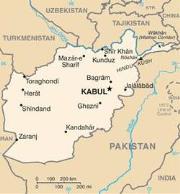
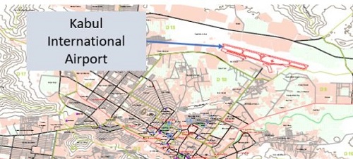
Kabul Airport - HKIA
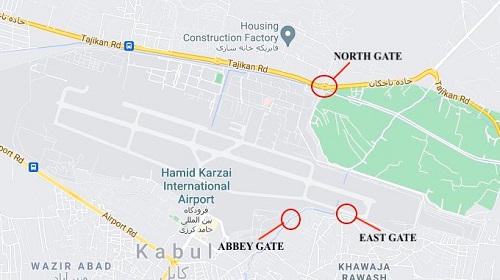
The airport was originally referred to as the Kabul International Airport or KIA. It was later renamed for the Afghan President Hamid Karzai and called Hamid Karai International Airport or HKIA. It sits at 5800 feet which limits aircraft performance - in addition it is surrounded by mountains. The airport is on the outskirts of Kabul to the northeast of the city. The civilian terminal is at the south side of the airport while the military terminal and ramp space is on the north side of the terminal. The runways run east west. The State Department has a support facility that ran flights to and from the U.S. embassy (and ISAF/RS compound) called Camp Alvarado. Security. The U.S. provided the vast majority of the forces to secure the military side of the Kabul airport. Assisting were Turkish, Azerbajian, Australian, British, and other foreign national contingents. Afghan Forces at Airport. Several hundred Afghan military and police personnel are assisting the international forces in maintaining security - primarily from Afghan SOF units that made it to the airport prior to the fall of Kabul. These include NDS Units 01, 02 and 03 as well as some ANA Commandos. When asked if the U.S. would bring these Afghan troops to the United States, Press Secretary Kirby said they must decide for themselves if they want to leave and would have to apply for visas. HKIA Entry Points for Evacuees. Currently there are three entry points for those wishing to board flights from the military side of the airport. The DoD stated on Thursday, August 19th that additional gates were being established - but no information on how many additional gates or where their locates were at the airport was provided. There are / were about seven different gates from which to access the miitary side of the airfield. Not all are in use at this time. HIKA Gates for Access to Military Side of Airport Listed in
CCW Direction.
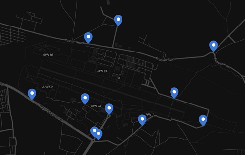
Taliban Checkpoints at HKIA. The Taliban have set up numerous checkpoints around the airport. To some extent they are preventing crowds of Afghans from swarming the entry points, yet at the same time they have been preventing Afghans with SIV documentation from gaining access to the entry points. A private entity has been mapping the Taliban checkpoints at HKIA. There is no way to verify the accuracy of this date in the image below (dated 0738 local time on August 20, 2021).
Medical Services on HKIA. There is a Norwegian military facility set up on HKIA that is providing emergency medical services. (Task & Purpose, Aug 19, 2021 and The Washington Post, June 15, 2021). And Bagram Air Field (BAF)? The U.S. military left BAF in the middle of the night in early July. Many critics asked why this was necessary. It is now becoming apparent to some that perhaps the U.S. should have maintained control of BAF as a contingency plan. Contingency plans had included for elements of the 82nd Airborne's Global Response Force to conduct a mass tactical jump to seize Bagram Air Field to facilitate the evacuation. The airborne insertion was called off and they diverted to HKIA. Read more on this in Bagram Airfield and NEO. Managing Airflow. One of the daunting tasks was how to keep the number of aircraft on the small Kabul airfield at a minimum. With just one runway and a parallel taxiway it was important to have a continuous flow of incoming and outgoing aircraft. HKIA was surrounded by the Taliban and thousands Afghans attempting to board evacuation aircraft. The airflow was at first managed by a piece of paper taped to the windshield of a vehicle. This was replaced by a Microsoft Excel spreadsheet; but this was hard to manage. Eventually a Google Docs spreadsheet was used that could be shared with users around the world. Read more in "How airmen used a single Google Doc to save thousands of lives during the Afghan airlift", Task & Purpose, January 16, 2023. Controlling the Skies Over Kabul. In mid-August a small group of Marines from the 24th MEU's Marine Air Control Group 28 Detachment arrived at Hamid Karzai International Airport to control the skies over Kabul. "How Marines brought order to the skies during the Kabul airlift", Military Times, May 30, 2023.
|
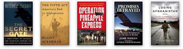
Books about the Kabul non-combatant evacuation
operation (NEO) of August 2021,
|
|